


Water and the Dutch
Blog - 9 november 2016Tijdens de conferentie 'Keeping history above water' in Newport (Rhode Island USA) onderstreept Matthijs de Boer het belang van blijvende aandacht voor duurzaam waterbeheer. We hebben in Nederland een jarenlange traditie waarbij waterbeheer en ruimtelijke ordening samen optrekken, hier is de volledige tekst (in engels) terug te lezen;
Keeping history above water by design
It must be clear: the Dutch have water running through their veins. The fact is, that we have a long history with water and we built up a strong love-hate relationship with water over the centuries. We conquered most of our land by pushing back the water, building dykes and windmills to create polders and to keep the low land dry. We deserved a reputation: God created the world, and the Dutch created the Netherlands, those guys who could make land out of water.
Ten years ago, my lecture at Roger Williams University was intended to convince you of the opposite: We learned that, to live with the continuous and growing threat of water, both from the sea in the west, from the rivers coming in at the east and the south, and from rain from above, we have to give it room. Give water the space it needs, learn to live with it and enjoy the advantages. That was, in two sentences, the message of my lecture then: Water, if you can’t beat it, learn to love it….
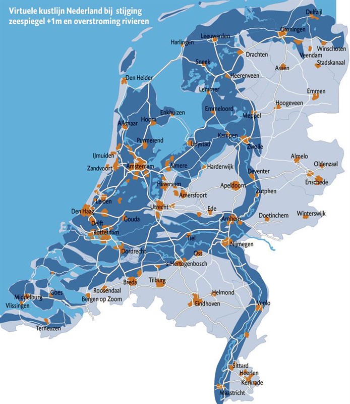
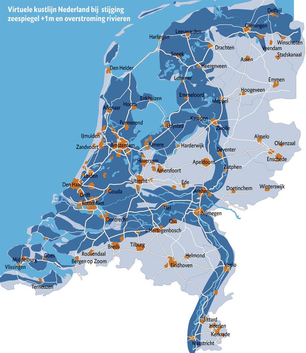
I am showing some maps of the Netherlands which look very much alike at first glance – for a reason. The first one, in white the land area in the Middle Ages, second, the flooding that would occur if there were no dykes today– basically the land below sea level plus the shores of the rivers, 3d, the flooding that will occur with a sea level raise of 1 meter, and finally, in a European context, what would happen if the Arctic ice cap would melt. The threat of flooding is serious business. I guess you understand: We got some work to do.
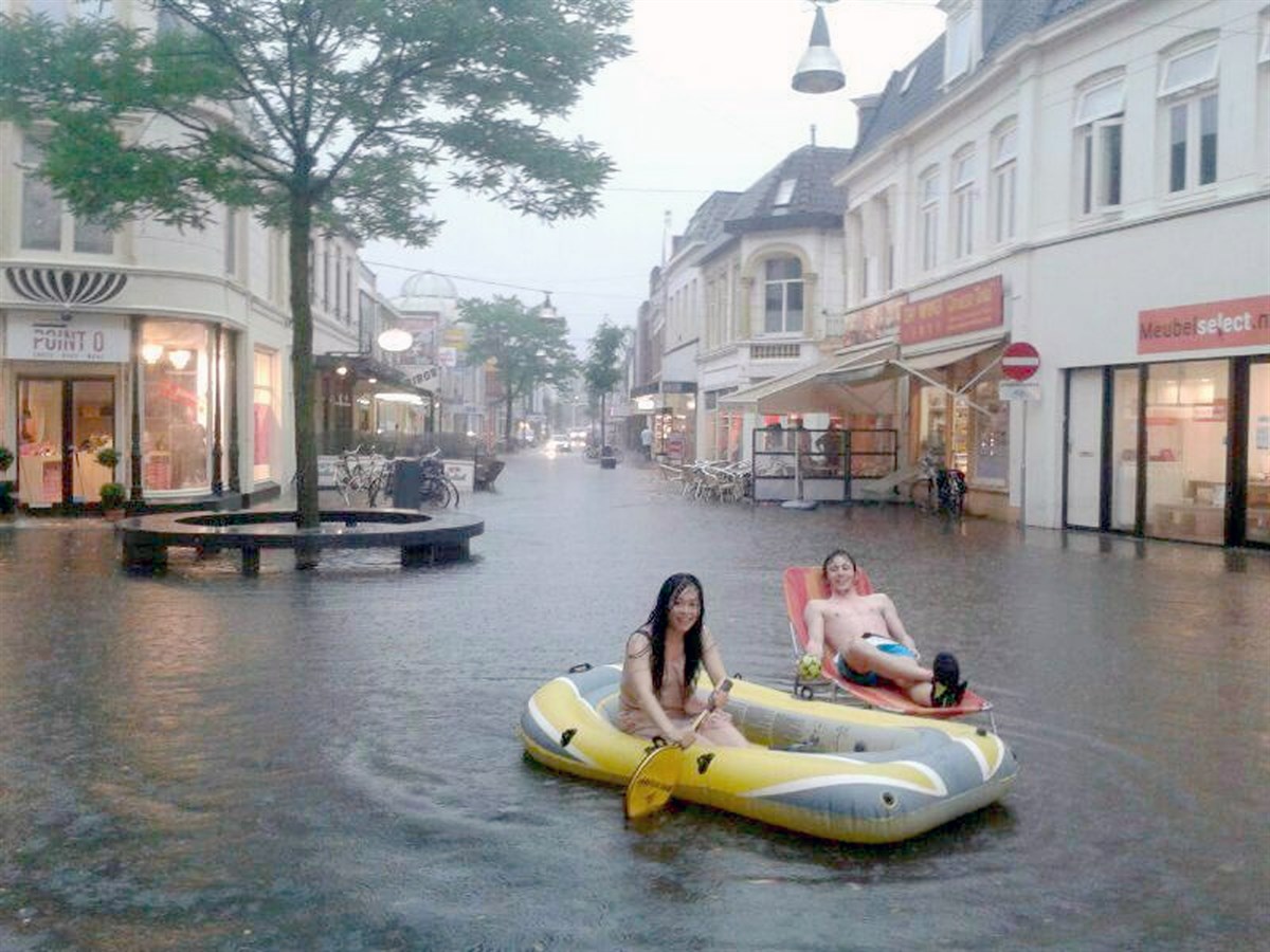
Or, learn to live with it, make the best of it, and enjoy it. The Dutch have built up some experience living with water and flooding. (and of course the bicycle is involved. But I can tell you: the enjoyment is fun only for a short time, the disadvantages last longer.
The countless numbers of memorial stones in buildings that show the highest water level from an historic flood bear witness of that. These stones are part of our built heritage and they are important to keep people alert.
My first statement: Make the risk of flooding visible to create awareness. Awareness is an important factor to enhance support for necessary measures which are often drastic and costly.
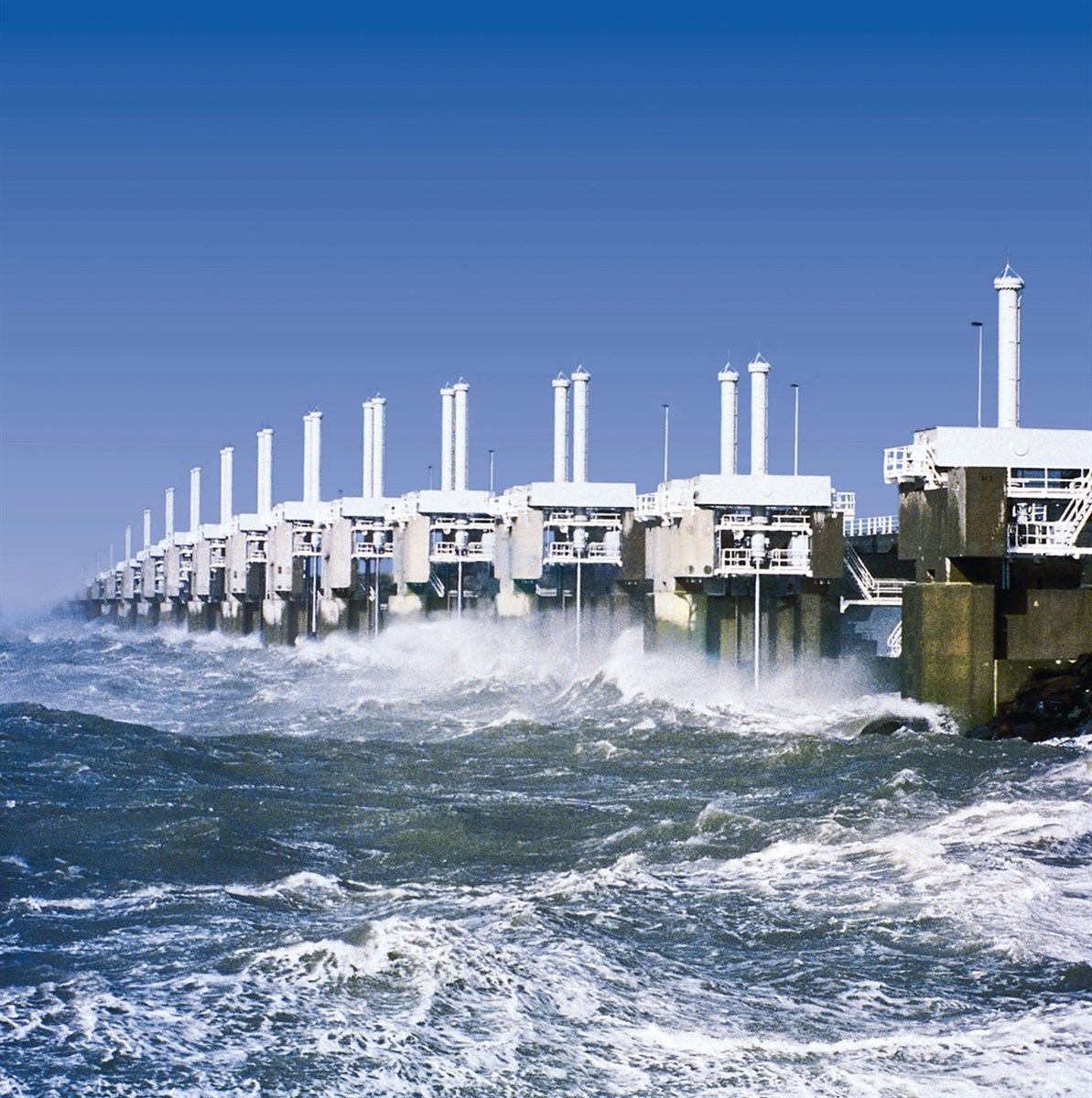
I will show two important Flood Barriers, both part of the Delta Works, and both designed to allow water to flow through in normal conditions and to retain the water when there is a risk of flooding. Also: both monumental in character and part of our cultural heritage.
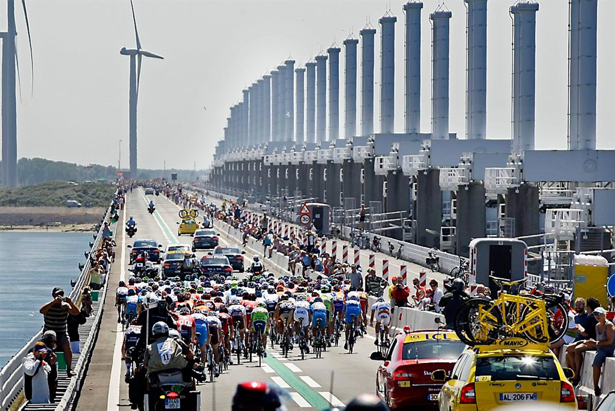
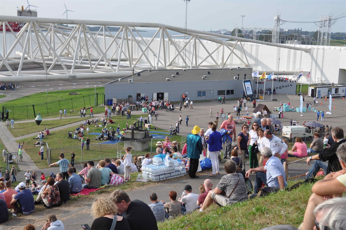
First the Oosterscheldekering: Not only a flood barrier, but also a major tourist attraction, affectionately named Neeltje Jans, Dutch for Nehalennia, goddess of the sea.
It is no coincidence that the Tour the France, when the start was in the Netherlands, passed over the Oosterscheldekering; and thousands of children learn to deal with water here.
Secondly, the Maeslandtkering tells a similar story. This is more than just a technological solution to a practical problem. This is also a cultural act.
Like Neeltje Jans, the Maeslandtkering is very well designed, impressive and beautiful. It is the perfect destination for an educational trip, or just a day out.
The comparison with the Eiffel Tower is not just about dimensions – they both became cultural heritage – the difference is that the Maeslandt serves a purpose…
The message here is, my 2d thesis: Don’t be afraid of bold design: we must make new landscapes with qualities similar to our historic landscapes. If well designed, the new landscapes will be the monuments of the future.
Case 1: Dorpsstraat Capelle aan den IJssel
A small example to show that the Dutch don’t do everything perfect – We are still learning and developing knowledge and methods. In the tiny historic centre of the larger town Capelle aan den IJssel, close to Rotterdam, the dike has to be replaced by a stronger one – not much higher, but wider in this case. This will be done according to the specifications from the engineers of course. The landscape architect follows their conditions.
The lack of interaction between landscape architect and engineers early in the design process influenced the final result in a negative way. All the trees standing in the future technical profile had to be removed, because of the chosen construction of the dyke, which was the traditional one – not to mention that it was also the cheaper one. The buildings will be saved, but the –historic- environment will change dramatically. The characteristic steep slope will disappear, and so will all the trees.
If the importance of the trees for the historic village would have been pointed out from the start, and landscape design would have been integrated in the process instead of added later on, another type of dyke improvement might have been chosen, with an underground steel or concrete retaining wall.
Well, after all, some people are happy now because the space that was gained by removing the trees will be turned into extra parking space. (like Johan Cruyff, our most famous soccer player and popular philosopher, who passed away last year, would have said: “Every disadvantage has its advantage”). But my 3d thesis here today is: integrate necessary measures in urban or landscape design. If historic buildings are at stake, care for their setting as well.
Case 2: Voorstraat Dordrecht
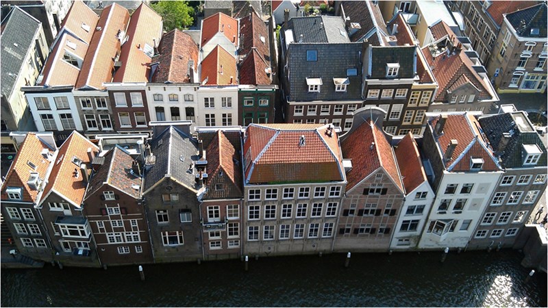
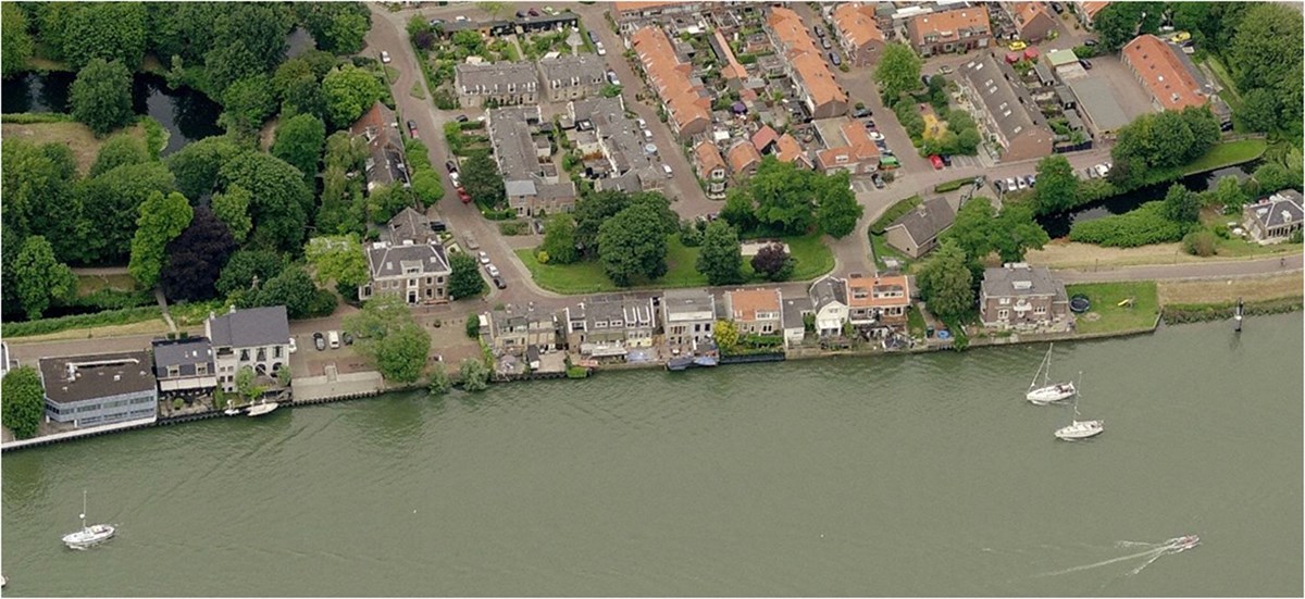
The second case I would like to mention is the Voorstraat in Dordrecht. Dordrecht is one of our oldest cities, got its city rights in the early 13th century. Situated at a very strategic location at the intersection of 3 rivers, the town and its surroundings suffered severely from the St. Elisabeth’s flood of 1421. You may wonder – where is the city in this picture? The flood took it’s toll, left the city on a small island, which is seen in a larger picture here and finally also created an important nature reserve, the Biesbosch.
This is what Dordrecht looks like today- and this was the situation just after the major flood of 1953. (We may call Dordrecht ‘The Venice of the north’ – even though nobody would call Venice ‘The Dordrecht of the south’…. But this old Dutch town is really worth a visit).
The Voorstraat, really is a line-up of monuments, which includes the urban structure itself, being both Dike and street. It is the Lowest sea dyke in the country, and impossible to raise. Lifting the whole street with all its buildings would be practically impossible and would destroy the authentic heritage anyway.
But apart from being heritage, it is also just a normal urban shopping street. This shop however is not really a shop but an exhibition gallery, dedicated to the problem of raising water and its solutions. Note that the signing says: “Our water”, affectionately, hinting on our love-hate relationship with water. Inside is an exhibition about flood measures in Dordrecht and in the Voorstraat in particular. (where V.I.P.s come for networking and the next generation to learn) Dordrecht organizes a website, an exhibition, water labs, self help courses, and photo competition on the theme “Dordrecht and our water”.
And, last but not least, the yearly practice test placing Flood Barriers. Every year again it is important to explain to the shopkeepers that the Flood Barriers are not meant to keep the water out of the buildings but to keep it in and save the street and the land behind.
It may seem primitive, but if Dordrecht does it this way, you may assume that nothing else is possible here… As mentioned before, self-reliance is also an issue, and an important part of the yearly training sessions. It can be quite cosy in the attics of de Voorstraat.
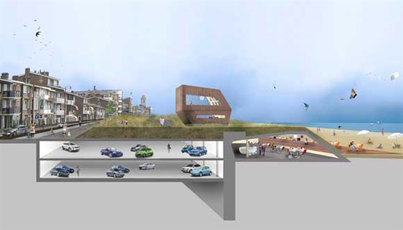
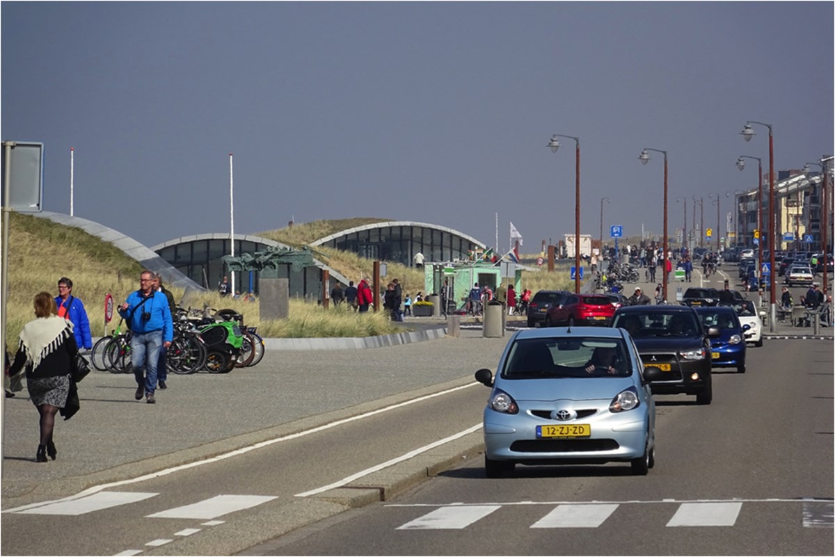
Case 3: Boulevard Katwijk aan Zee
Katwijk is a small coastal town with a large, but small-scale tourist industry. As one of the last parts of the Delta Works, the sea dike, which used to go around the oldest part of the town, leaving it unprotected, is replaced by a new Deltadijk. Here, the very diverse programs of the shoreline area, like protecting the village against the sea, parking cars, strolling on the Boulevard, and walking to the beach, are integrated in the planning process from the beginning. With an obvious win-win as result.
Here, in a few drawings, the quintessence of the design by Okra landscape architects.
What I want to add to that functional combination, is of course the good design, and the beauty of the resulting landscape. Summarizing my advice that flood measures be visible, integrated in the urban design process, and well designed.
Matthijs de Boer, april 2016